|
Mesa Verde National Park |
||
|
|
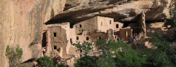
Mesa Verde (Spanish for "green table") rises high above the surrounding canyon country and served as a home for ancient pueblo tribes. They used the mesa top as agricultural land and the surrounding canyons as dwelling sites. (NPS photo on left) | |
|
DiscoveringColorado.Com Home
National Parks •
State Parks •
Cams •
Skiing •
Photos
Cultural evidence of the Ancient Pueblo People dates back to 550 A.D.
Archaeologists have provided evidence that determines the ancient
culture lived in the Mesa Verde area until the 13th century.
Exactly why they left the area is a mystery, because no written
materials were left behind by the Pueblo People. The ruins were
discovered in the 1880s and after much scavenging and looting the area
was made a National Park (1908).
Mesa Verde National Park is located on Highway 160, 36 miles west of Durango and ten miles east of Cortez, Colorado. It lies in the southwestern corner of Colorado. The Mancos Canyon and River form the eastern rim of the Mesa. If you look at Mesa Verde on a topographical map you will see that it is riddled with canyons and creeks flowing to the Mancos River. South of the park lies the Ute Mountain Indian Reservation and Tribal Park.
For more information on Mesa Verde,
click here.
|
||